
|
"We sat down on the very edge of the wall, and strove in vain to penetrate the mystery by which we were surrounded..."
-JLS |
|
John Lloyd Stephens and Frederick Catherwood |
|
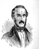
John Lloyd Stephens was born 28 November 1805 in Shrewsbury, New Jersey, graduated Columbia with a law degree, and practiced law in New York until he was diagnosed with a throat infection. Following the advice of his doctor, Stephens left New York for a change in climate and traveled extensively through Europe, the Mediterranean, Asia Minor, Palestine, and Egypt. These travels would result in the publication of his first two books, Incidents of Travel in Egypt, Arabia Petraea and the Holy Land (1837) and Incident of Travel in Greece, Turkey, Russia and Poland (1838) both of which were immensely popular and earned Stephens the nickname `the American Traveler'.
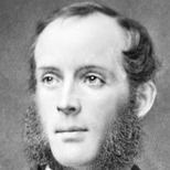
Frederick Catherwood was born 27 February 1799 in north London and, by his twenties, was already well known as an architect, artist and traveler. He had already published his drawings of structures in Egypt, Palestine, Asia Minor, and Greece and, in 1833, was the first westerner to survey and draw the Dome of the Rock in Jerusalem. The two men met in London in 1836 where Catherwood's panorama `The Ruins of Jerusalem' was on display. Both men were interested in exploring the region so vividly depicted in the published accounts of Mesoamerica by earlier explorers like Antonio del Rio and Juan Galindo and the drawings of Mayan sites by Jean-Frederic Maximilien, Comte de Waldek. They agreed to travel together to the region at the first opportunity.
Stephens was famous enough as a world traveler and writer to have President Van Buren appoint him Ambassador to Central America from the United States and he and Catherwood left New York for British Honduras (modern day Belize) on 3 October 1839. Though conscious of his diplomatic duties, Stephens was primarily interested in exploring the ancient ruin of Copan and then moving on to Palenque. At this time, many of the now-famous Maya sites were unknown even to the indigenous people of the region. The centuries had slowly covered the great temples and pyramids and turned them into mounds of green hills. Only a few cities of the Maya were known to exist at this time, among them Copan, Palenque, Topoxte/Tayasal and the mysterious unnamed city deep in the jungle (which came to be known as Tikal). There were no accurate maps of the region and the two men often discovered sites through word of mouth in conversation (one example of this being Catherwood's discovery of Quirigua). They traveled without any of the extensive entourage which usually accompanied 19th century explorations. They had only a guide, some men to carry equipment, and a crudely drawn map which they had already been told was inaccurate. Even so, this did not stop them from exploring the jungles of Mesoamerica in search of the ancient sites which they had heard of and read about.
Having mapped and recorded the site of Copan, they moved on through the jungle, mapping and recording sites such as nearby Quirigua and Zaculeu on their way to Palenque. The work they did lay the foundation for all future study of the Maya civilization. They meticulously documented the sites they visited, carefully charted the courses they took, and logged the time in travel between one site and the next. In reading Stephen's narrative, and following the maps drawn by Catherwood, other explorers were able to expand upon their work to bring the Maya Civilization to light. In 1857 Desire de Charnay arrived in the region and used their work to help chart his own exploration to more Mayan sites. Teobert Mahler also made use of their books in his photographic journey of the sites in 1876. In 1891 Sir Alfred Percival Maudslay came to the region and dramatically changed the scope and depth of all further excavations. Maudslay is understood as the first explorer to employ a strict scientific method in excavating and examining the sites of the ancient Maya. He helped to preserve and protect many notable sites and set the standard for future expeditions and excavations. Following Maudslay, many very notable explorers made further great advances in clearing, documenting, and photographing the Maya sites. William Holmes began work at Palenque in 1895, the same year Teobert Maler documented Tikal, and was followed by Alfred Tozzer. In 1914, Sylvanus Griswold Morley first came to the region, best known for leading the team which excavated Chichen Itza in 1923. In 1925 Franz Bloom so extensively documented Palenque that his work, like Morley's, remains important reference material for Mayanists in the field today. In less than one hundred years since Stephens and Catherwood began their first journey, the Maya Civilization had become recognized as one of the greatest produced by the ancient world.

